William P. Reimann
  • Home
  • "Aerial VIII"
  • Art
    • Plexiglas™ & Steel >
      • Plexiglas™ & Steel
    • Stone >
      • Stone
      • River Roundies
      • Abstract Panel Sculptures
      • Heritage Series
      • Holyoke
      • Cambridge Parks
      • Rousseau
      • Hand-carved Furniture
      • Metal & Glass
      • Piers Park Pavilion
    • Wood
    • Wood >
      • Metal & Glass
      • Rhinoceros
      • Pistachio Bowl
    • Radnor Township
    • Drawings
    • Ephemera >
      • Nutik
  • Current: the Zietlow Trophy
  • Curriculum Vitæ
  • Archive
    • Archive Metalwork & Glass
    • Archive Drawings
  • Contact
  • Will's Blog

Radnor Township

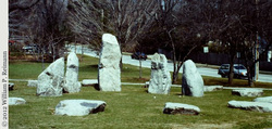
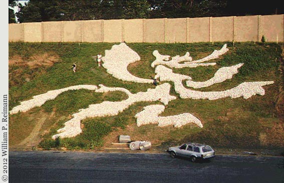
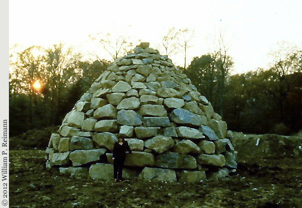
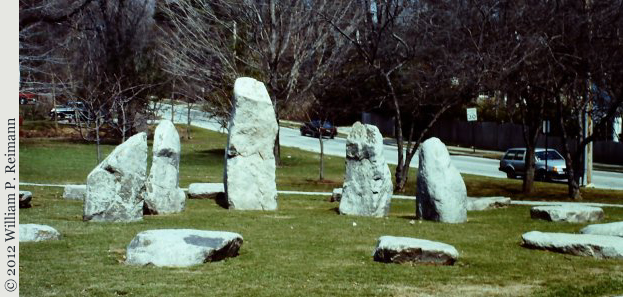
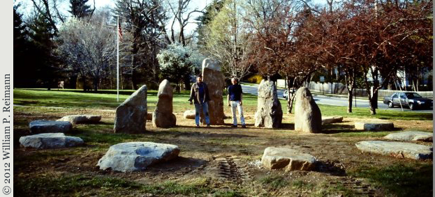
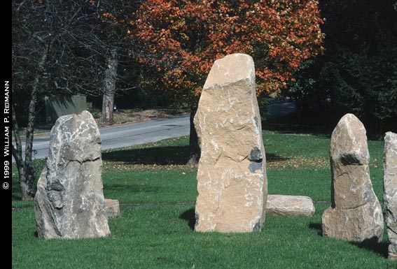
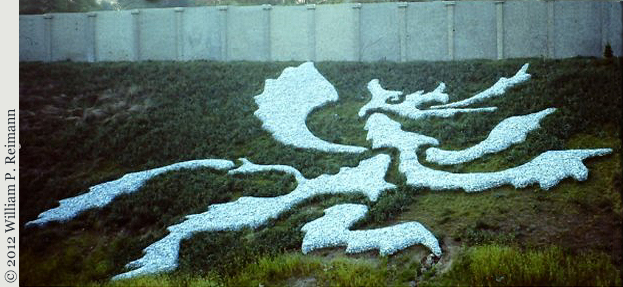
In the late 1980s, the Radnor Township was designated for highway development. The town was strongly in need of a coherent strategy in the art projects that were to be developed as "placemaking" compensation for the incursions of a four lane highway on their land.

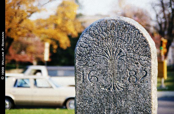
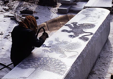
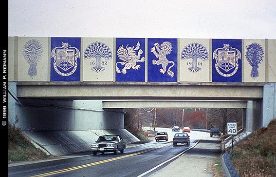
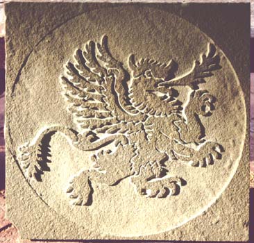
Will drew on the historic Welsh settlement of the area for his ideas, adapting a series of images that had been used on the town seal since the 17th century.

Using a variety of materials including selected stones dug free during the course of the road work, he created a striking and diverse series of permanent installations: a monumental cairn, a stone circle, a gigantic hillside griffin.
June 2021: these pages are being reorganized and updated (especially the image quality)

Stone Circle

Picture
Mysterious stone circles, over three thousand years old, dot the countryside throughout the British Isles. Their exact function remains unknown. In some of the more elaborate constructions, the stones are aligned so that a single ray of light penetrates between two standing stones to a central altar stone at either one of the equinoxes or the solstices, suggesting that these circles were used like a large scale sun dial, or for astrological calculations.

Radnor's circle calculates neither the time or the seasons--however, the work does have some small level of concealed symbolism.  Will worked with a crew of four to erect the stones. When he came to select and then position and raise the five blocks for the uprights, he chose one stone for each of the crew. These five variously dark, stocky, short and tall stones stand in permanent reference to the men who raised them.


Limestone Spawl
(11' rough-cut blocks)
sourced from Norristown, Pennsylvania

Hill Griffin

Picture
This enormous stone cobble griffin was inspired by ancient hill paintings in the British Isles where the thin layer of grass and topsoil was scoured away by ancient tribes to reveal the white chalk below. 

Ancient images that have survived into the 20th century include human figures, horses, and dragons.

Radnor's Griffin measures eighty by one hundred and twenty feet. 

The Great Cairn

Picture
Stone for the circle and the cairn was 'quarried' on site as work progressed for the Blue Route highway.  Will selected the monoliths, glacial accidentals and "shot-blast" boulder-stones as the great machinery of the road cracked them out of the earth.

This provided a substantial savings for Radnor Township--and, Will felt, was also a great use of the local stone.  Since its installation in 1997 (viewable, along with the Hill Griffin, via Google Earth at the Blue Route's E. Lancaster Avenue exit), Will's cairn has been the subject of much speculation.  Is it an Indian mound?  A viking marker?  To Will, it references the shepherds' cairns high in the rocky Welsh hills.

Click on the Google Map, left, for a view of the the Griffin.  The Satellite image gives the best view, with the Griffin clearly in sight just to the upper left of the center.

The map can be manipulated to show the Cairn (sadly, the lack of street address prevents both artworks being shown "up front" on this iteration of the page/map).  Put the cursor over the griffin, and gently drag the griffin to the right edge of the map.  The Cairn will appear, with an obvious access path, on the left.  Zoom in for a closer look!

Radnor Township

Picture
Radnor was legally incorporated in 1682. The early Welsh settlers created a town seal with five images: a griffin, a lion, a wagon, a wheat sheaf, and a 'Tree of Life' (an image derived from the bible). These elements used throughout the project to embellish overpass bridges, mile-markers, a 25' granite obelisk and an elaborate glockenspiel clock with moveable mechanical figures.

The images symbolize the history of the township: their allegiance to their former home (the heraldic symbols of griffin and lion), their spiritual hopes (the Biblical tree of life), and the long journey (the wagon) that they had undergone to reach their new home.

In past times, mile markers served to welcome travelers as they neared their destination.  Will  created markers at several points of entry into the town, once again using elements from the town's seal.

Powered by Create your own unique website with customizable templates.
  • Home
  • "Aerial VIII"
  • Art
    • Plexiglas™ & Steel >
      • Plexiglas™ & Steel
    • Stone >
      • Stone
      • River Roundies
      • Abstract Panel Sculptures
      • Heritage Series
      • Holyoke
      • Cambridge Parks
      • Rousseau
      • Hand-carved Furniture
      • Metal & Glass
      • Piers Park Pavilion
    • Wood
    • Wood >
      • Metal & Glass
      • Rhinoceros
      • Pistachio Bowl
    • Radnor Township
    • Drawings
    • Ephemera >
      • Nutik
  • Current: the Zietlow Trophy
  • Curriculum Vitæ
  • Archive
    • Archive Metalwork & Glass
    • Archive Drawings
  • Contact
  • Will's Blog